What a joy to read John's splendid post of the Puncak traverse! John and Jody have opened my eyes to some alternative routes that I have never explored since I began walking the foothills in 1991. Sorry I couldn't join you that day but thanks for the invite.
I now link back to a 30 October posting about the C3 detour on my blog. Your journal illuminates an important alternative exit for route C3. After climbing from the ex-outpost (point C) to Pr Mandalawangi and reaching point D, one can return to point B by way of Gn Joglo, as you have done. This circuit would be less hazardous than the ascent to the Puncak and would bring one back to the Start. Further, I remain curious about the path leading up Gn Gegerbenteng from the saddle point on Pr Mandalawangi, mentioned on 30 Oct. The path was not there some years ago when I passed this way. Given the deteriorating conditions on the Gn Gegerbenteng traverse, I would not be surprised if the locals have opened a new traverse higher up the mountain. I look forward to exploring this alternative myself next year, if someone else does not get there first.
I am curious about your route beyond point B. In your place, I would probably have gone from point B to point A, then turned left on the stone road and contoured around the upper end of the tea plantation, where you seem to have ended up anyway. Which of these routes looks preferable to you?
At the rate you guys are going, you'll soon finish trekking the ring route in sectors B, C, D, and E. You are innovating as you go along. How'd you like to write a guidebook to the ringroute in those 4 sectors, with photos and GPS coordinates?
Sunday, December 21, 2008
Saturday, December 20, 2008
Pitcher plants in Puncak

I'd like to add a couple of photos to the account of the Cibodas to Taman Safari walk below.
Besides the large mushroom in the picture we also found a small pitcher plant during the ascent of Gunung Joglo. Does anyone know if these are common in the Puncak forests? Are there lots of different kinds? Are they climbers or ground-growing? We haven't found many, but perhaps that's because we haven't been looking very closely!
The view is looking down toward the Puncak Pass hotel and surrounding area from Pasir Pangsalatan, just before reaching the Puncak ridgeline. To the right is the view back toward Cipanas from the same spot. This section of the route is quite thickly wooded so we were lucky to find a small opening in the vegetation to shoot these pictures.


Sunday, December 14, 2008
Cibodas to Taman Safari- A Puncak Traverse
After our November walk between Taman Safari and Arca, we contemplated the next enticing stage of the ring route, a traverse across the Puncak ridge from Cibodas on the Cianjur side to Taman Safari on the Bogor side. Although it would be possible to break this into shorter sections, the prospect of connecting Puncak's two most celebrated tourist attractions- Cibodas Botanical Gardens and Taman Safari Indonesia- with a single "classic" hike was too enticing to resist.
And so it was that we (i.e. Jody Randell and I) set out on Saturday December 13th, starting at 6.30 from just in front of the large entrance toll gate to the Cibodas recreation area.
Using the Sector D (Cipanas) map we mainly followed the red ring route arrows, (though of course in the reverse direction to that marked on the map). From the crossroads 100m below the gate, descend northwest and take the footpath to the left of the lone villa. This turns into a comfortable asphalt track that winds into the valley past a dilapidated tennis court. Take the footpath on the left shortly after the tennis court, cross the concrete footbridge over the stream, cross the vegetable fields for 50m and then head left up the slope toward Hartono garden. (We must have missed the earlier stream crossing marked on the map.)
Enjoy the fine views back toward the villages along the Cibodas road and then enter the cool shade of the beautiful Hartono garden, keeping on the uppermost of the various flower-lined footpaths. (The more leisurely D1 circle route allows ample time to explore the gardens in all their glory.) Exit the garden at the north gate, continue 100m or so and then head right up the slope through the cabbage fields. We got lost in the tomatoes but the farmers were there to set us back on the right track, past the large water tanks onto the ridge top. Once there, one's position is unmistakeable as it affords sweeping views of Kampung Gegerbentang in the valley on the north side, Gede and Pangrango beyond the forest to the south, and all the hills and plateaux of the Cianjur regency spread out behind you.
Heading up the ridge we passed a plantation of temptingly juicy arbei and then, 1 hour 30 minutes after setting out, we entered the forest, passing a wooden sign marked Pasir Buntu. The first section in the forest is a pleasant stroll on a narrowing, with occasional vistas right beyond the Cibodas parking area and on to Gunungputri village (start of the D2 circle route). Freshly painted steel posts have been planted every 100m along the route, which is obviously popular with woodcutters. (At this point we transfer from the western edge of the Cipanas map square D' to the eastern edge of the Cisarua map square J.)
After the 1000m marker the path forks, with the steel posts taking the right fork to Legokbabah and our ridge path heading left, marked by friendly orange ribbons tied on a tree here and there. The heart poundingly steep stretch begins as you approach 1500m altitude but the path is mostly dry and offers a firm footing. Higher up the gradient slackens but the path becomes tougher as it veers right off the ridge line and becomes narrow and treacherous. To compensate, the occasional clearings in the vegetation afford broad views across to the Puncak watershed, the radio towers familiar from the C3 and C4 circle route, and all the hotels, villas and restaurants on the Cianjur slope.
Eventually, with 5.5 km covered in 3 hours shown on the GPS, we reached the four-way junction on the Gegerbentang ridge, a comfortable rest stop with enough space to pitch a tent. From here, the summit of Gegerbentang (2042m) is temptingly close, less than 200m above us. But with many kilometers and an unfamiliar trek over Gunung Joglo still ahead of us, we decided to leave the summit for another day. (The quickest route up and down is probably from Cibodas and back down the same way, or descending directly to the Puncak highway.)
From this junction, our route (the middle of the three paths before us) contoured around the northwest slope of Gegerbentang, passing over plenty of fallen trees that threatened to block off the route but never quite did. The distant wail of the loudspeakers from Cibodas, that had accompanied us on the ascent, was replaced by the alternative wail of the speakers from Gunung Mas, wafting in and out of the mist that now shrouded us against the wooded slopes. After reaching our day's high point of 1900masl we descended the western ridge of Gegerbentang. After several hours on unfamiliar paths, the fourway clearing which is point D on the C3 circle seemed comfortingly familiar and pleasantly silent, as the loudspeakers finally faded completely. At this point we were 7.9km and four hours from our start point, but fortified ourselves with sandwiches and fruit.
(On the map the marked ring route passes through Kampung Mandalawangi, point C on the C3 circle route, and then follows the lower C3 path along the side of the valley.
Alex, in his trekking blog
http://puncaktrek.blogspot.com/2008/10/high-altitude-detour-on-route-c3.html
describes two routes for passing from Kampung Mandalawangi to the Puncak ridgeline as part of the C3 walk. One route involves ascending from Kampung Mandalawangi to the 1900m high point mentioned above, then descending as we did to the point D clearing where we stopped for sandwiches and continuing the C3 path as marked on the map. The second route involves ascending from Kampung Mandalawangi to the 1900m high point, then contouring around Gunung Gegerbentang to the fourway junction on the Gegerbentang ridge i.e. our route in reverse, and then descending toward the main Puncak highway.
I walked the C3 route twice last year; the first time it was hard to find the marked trail from point C to point D and both times it was hard to find the last section of the trail approaching point E as the path seems to peter out in some secondary forest growth. As an alternative route from point C to point E, I guess it would be best to follow Alex's second route, asending from Kampung Mandalawangi to the Gegerbentang west ridge, and then contouring around to the Gegerbentang north ridge. The path was treacherously slippy but easy to follow whereas the D to E path marked on the map was treacherous and difficult to follow.)
But now let's conclude our sandwich break at the C3 point D clearing and begin the traverse westwards over Gunung Joglo.
From the clearing the Gunung Joglo path first descends to a broad saddle and then rises again before following a flattish ridgeline. The path here is surprisingly well-trodden and marked by blue ribbons strung on trees. There are a couple of indistinct passages and one section atop a small knoll in serious need of a machete, but on much of the flat ridge top the tree cover is light and the path remarkably reminiscent of a walk in the park! The only obstacles are the inevitable thorny creepers and occasional low-hanging branches. Keep in mind also that this is leech country. Leech haters can take the well-known precaution of dipping socks in tobacco juice, while the more leech-friendly might simply wait for a rest stop before hauling the little creatures out from under a bootlace and flicking them away.
The summit of Gunung Joglo (1844m) is a broad, thinly-wooded knoll with a large space for several tents, though still pleasantly free from the plastic garbage that often mars forest shelter sites. On the west side the path soon starts to drop quite steeply; the cautious will tread gingerly throughout the descent. Eventually there is an almost sheer 3 meter drop requiring hand holds and the path joins the C3 circle route in a grassy clearing. Head right for 50m, then left to descend to the narrow shelf which is point B on the C3 route.
From this point, which we reached 6 hours 30 minutes and 10.8 km after setting out, the shortest exit, and the safest in bad weather, would probably be to turn right along the C3 path down to the Gunung Mas plantation and out via the tea tracks. We, however, set our course for Taman Safari, taking the path down to the left. After passing a large camping area, where there is also a path diverging up the slope, the route desends steeply; if anything it is steeper, trickier and more overgrown than the route down Gunung Joglo. Avoid the woodcutter's path off to the right, which appears to be a dead end, and keep descending until you come to a t-junction where a white plastic pipe runs just under the soil. A few meters to the left water gushes from a hole in the pipe, offering a welcome chance for a wash and a drink refill.
The path to Taman Safari heads to the right, following the pipe downwards and passing a concrete dam before finally joining a betterl-trodden and flatter path. Head right here to pass a raised concrete water tank and then hear a stream that comes in from the right. Just before the stream is a grassy trail on the left toward Taman Safari. Our hope of a shortcut to the tiger enclosure was foiled however by the park's wire boundary fence, a steep drop on the other side and some vicious stinging nettles that will plague anyone who has survived the pricks and thorns of Gunung Joglo unscathed. We returned to the stream, crossed it and then contoured up out of the valley, looking across to the park's spreading flame trees and African tulip trees, nestled beneath us. As we came down Gunung Joglo we had begun to hear the loudspeakers and exultant shouting of the visitors at the outbound center, and now we were able to glimpse them, as well as a few cars touring into the herbivore section of the park. While walking the C2 route last year, we even manged to spot zebras and elephants, but on this occasion they appeared to be well-concealed under the shady leaves.
On emerging from the valley the complexion of the landscape changes again and you face tea plantations with their crisscrossing paths, neatly spread villas and their manicured lawns, a sharp contrast to the dense, unruly vegetation of the last eight hours!
Turn left as you enter the tea and follow the boundary on the left between the plantation and the scrub for about 200m. Dip out of the tea plantation onto a narrow footpath to the left, hemmed in by the mesh boundary fence of Taman Safari on one side and an iron fence marking off land for villa construction on the other. Over the precipice on your left are the auxiliary buildings and entrance roads to Taman Safari, reminding you of the impressive size and scale of the whole enterprise. This path emerges at the corner of a field, where you proceed right for 30m to find the head of an asphalt road.
At this point the rain, which had been menacing all afternoon, finally began to teem down. The timing was fine by us as from this point the walk is simply a pleasant jaunt past the intriguingly varied villas, including several under construction, of the Cibereum hillside. At 4.00p.m., 9 hours 30 minutes and 17 km after starting out, we rolled into the Cibereum market square to indulge in warmly grilled corn and somewhat less warm beer.
What a satisfying hike! How glorious that travelling from Cibodas to Taman Safari can mean so much more than a traffic jam! What a sense of new vision one gets from linking those two so familiar landmarks of Puncak tourism in a novel, and, for us, previously unimagined way!
I would certainly be interested to hear from anyone who has walked this route before.
For anyone thinking of following us I can recommend the route highly, although one should certainly become comfortable first using the WIPA maps and hiking over the various kinds of terrain shown on them, as this is an arduous day's hike. But we went at a sedate pace, and fit and experienced walkers would probably require much less than our 9 hours 30 minutes.
It would be a challenge to cover the route in the opposite direction, from Taman Safari to Cibodas, but I believe our route was preferable. First, for those returning directly to Bogor/ Jakarta, it cuts down the potential length of the traffic jam on th eride home! Second, it involves less climbing, starting from 1280m, climbing to 1900m and then descending to 1070m. Third, the most spectacular scenery, on the Pasir Pangsalatan above the Hartono garden, is encountered early in the morning, before the clouds roll in. Fourth, the most treacherous parts of the hike, contouring around Gunung Gegerbentang, are also encountered fairly early on, before fatigue saps away the balance and spring that are necessary to keep a safe footing on the subsiding footpaths.
I hope the above description inspires a few people to head out and explore the beautiful Puncak countryside. Our walk certainly inspired us to feel gratitude and respect for the people who originally cut the trails, and the people who mapped them!
Monday, December 8, 2008
Top Teen Trek
This posting was prepared by Robert Baldwin, who lives in Pancawati.
This was a 2-day hike with high school kids from the British International School, their second venture with me into the foothills of Mt Pangrango.
We started from Cipare at 9:30 on Saturday 6 December. Good weather meant the views of Mt Salak on the walk to Pancawati village were terrific. The descent into Nangleng valley was slick, recent rains having created a few small landslides. We headed up the Pondokcatang ridge and breakfasted just before entering the forest at 10:30, the two streams below providing superb background music. This track is well-travelled, villages often using the trails to gather firewood. Small trails often lead out from the wood gathering stations. An hour into the forest and Will was struggling to keep up. Then he slipped, a sharp stick piercing the skin on his shin. First aid was applied, then we reached point B and turned right. The descent proved prickly, the rattan bordering this trail loved catching on backpacks, hats and clothes. The weather “gods” were extremely good to us and our descent into Luewisapi was bathed in sunshine. At 1:30 we lunched beside the Ci Mande then traversed Luewisapi village. A final rest in the valley the Ci Mande, before the hard slog out of the valley back to Pancawati by 3:30 pm.
All the teams pitched their tents. By 5 the tents were up, the rain had held off. Cameron fired up a bonfire. With darkness approaching all teams cooked themselves a “gourmet” meal. Ardy excelling in as chef and all seemed more than happy with their cooking results. Baldy’s barby of steaks and snags kept the leadership happy. By 8:00 cleanup was over and all teams were in their tents, a stiff breeze blowing. Tom was up barking orders at 05:15. The night had been cold, the sleeping fair, and the weather kind. Breaking camp took longer than anticipated. Backpack checks showed the trekkers had greatly improved their packing skills. Packs sat straighter and weight distribution was better.Some cooked breakfast, others ate snacks and pre-cooked food. By 7:15 the campsite was spick and span, tents packed away, trekkers full and ready for another day on the road. We walked back to Cipare to get buses to Pondokmentang. At Luewilarangan an aquaduct above the road threw a spanner into our “not-so-well-thought-out” plans. The 22 seater could not get under the duct, the air-con unit on top 10 cm too high. The smaller bus took the first group to Pondokmenteng and returned to pick the second group of hikers, who had meanwhile strolled on the LBC road. This was a bit like walking through the Jakarta Hamptons – lots of beautiful villas with manicured gardens. We left Pondokmenteng to follow the Ring Route to the northeast at 8:30.
The grand old daddy of Puncak trekking, Alex Korns, joined us at Pondokmenteng. Again the weather was great. The valley trails were still slick early in the morning, all trekkers spending time on their rumps, slipping and sliding on descents. With time lost early, new schedules were set and the hike’s tempo increased. We crossed the Ci Pondokmenteg, the Ci Bedug, the Ci Salada, and the Ci Ledug.With noon approaching we were ascending out of the last valley, the Ci Kereteg. The valley was magnificent, carpeted with Oz green padi fields, bordered by lush forests at the top. A truly beautiful view to cap off a great weekend. We arrived at Arca at twelve, had lunch and listened to Alex’s narrative about the history of the German military cemetery at Arca. From Arca we walked the final 2k back to Sukaresmi to get back on the buses for Jakarta. All trekkers reached the buses with plenty still in the tank.Many, many thanks to all involved, to Tom for organizing the trip and providing superb leadership, to the teens – it was a real pleasure sharing a couple of days with you. To Empad, Entab, Jeje and Chandra for carrying drinks in and garbage out, to Nina for managing the camp site.
Wednesday, December 3, 2008
The Disappearing Gong-gong Bird
Since 1991, when I first began walking in the forests around the foothills of Gn Gede and Pangrango, I have become accustomed to the call of the gong-gong bird, the puyuh gonggong. The haunting double-hoot of this ground-bird can be heard over long distances. 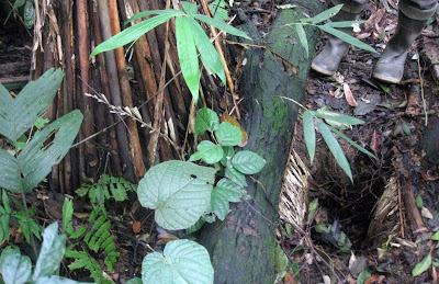 I have never seen this bird, and have recently begun to hear it less and less often. On Sunday 30 November, the reason for its gradual disappearance became clear, as I was walking with Robert Baldwin of Pancawati down the well-forested ridgeline of Pr Kramat, near to the village of Pancawati in sector B.
We were puzzled to see many holes in the ground beside the trail, that looked as if they had been dug recently with a shovel. At one of them, I saw an oddly-shaped inverted "basket" beside the hole. Our guide Pk Empad explained that this was an ingenious trap for the gonggong bird. There were actually two holes, one open and the other below the basket, with a "tunnel" between the holes. When in use, the open hole is to be covered with many leaves, so that a heavy walking bird might fall into the hole and fail to see any light above him. Instead, he would see light at the end of the tunnel, which would lead him to work his way into the second hole and thence up to the basket from which he could no longer escape.
"The gong-gong bird has become rare in the forest, most of them have gone to the city", joked the younger of our two guides. ("Burung gong2 sudah jadi langkah di hutan, kebanyakan di kota".)
 I have never seen this bird, and have recently begun to hear it less and less often. On Sunday 30 November, the reason for its gradual disappearance became clear, as I was walking with Robert Baldwin of Pancawati down the well-forested ridgeline of Pr Kramat, near to the village of Pancawati in sector B.
We were puzzled to see many holes in the ground beside the trail, that looked as if they had been dug recently with a shovel. At one of them, I saw an oddly-shaped inverted "basket" beside the hole. Our guide Pk Empad explained that this was an ingenious trap for the gonggong bird. There were actually two holes, one open and the other below the basket, with a "tunnel" between the holes. When in use, the open hole is to be covered with many leaves, so that a heavy walking bird might fall into the hole and fail to see any light above him. Instead, he would see light at the end of the tunnel, which would lead him to work his way into the second hole and thence up to the basket from which he could no longer escape.
"The gong-gong bird has become rare in the forest, most of them have gone to the city", joked the younger of our two guides. ("Burung gong2 sudah jadi langkah di hutan, kebanyakan di kota".)
Subscribe to:
Posts (Atom)