This posting was prepared by Robert Baldwin, who lives in Pancawati.
This was a 2-day hike with high school kids from the British International School, their second venture with me into the foothills of Mt Pangrango.
We started from Cipare at 9:30 on Saturday 6 December. Good weather meant the views of Mt Salak on the walk to Pancawati village were terrific. The descent into Nangleng valley was slick, recent rains having created a few small landslides. We headed up the Pondokcatang ridge and breakfasted just before entering the forest at 10:30, the two streams below providing superb background music. This track is well-travelled, villages often using the trails to gather firewood. Small trails often lead out from the wood gathering stations. An hour into the forest and Will was struggling to keep up. Then he slipped, a sharp stick piercing the skin on his shin. First aid was applied, then we reached point B and turned right. The descent proved prickly, the rattan bordering this trail loved catching on backpacks, hats and clothes. The weather “gods” were extremely good to us and our descent into Luewisapi was bathed in sunshine. At 1:30 we lunched beside the Ci Mande then traversed Luewisapi village. A final rest in the valley the Ci Mande, before the hard slog out of the valley back to Pancawati by 3:30 pm.
All the teams pitched their tents. By 5 the tents were up, the rain had held off. Cameron fired up a bonfire. With darkness approaching all teams cooked themselves a “gourmet” meal. Ardy excelling in as chef and all seemed more than happy with their cooking results. Baldy’s barby of steaks and snags kept the leadership happy. By 8:00 cleanup was over and all teams were in their tents, a stiff breeze blowing. Tom was up barking orders at 05:15. The night had been cold, the sleeping fair, and the weather kind. Breaking camp took longer than anticipated. Backpack checks showed the trekkers had greatly improved their packing skills. Packs sat straighter and weight distribution was better.Some cooked breakfast, others ate snacks and pre-cooked food. By 7:15 the campsite was spick and span, tents packed away, trekkers full and ready for another day on the road. We walked back to Cipare to get buses to Pondokmentang. At Luewilarangan an aquaduct above the road threw a spanner into our “not-so-well-thought-out” plans. The 22 seater could not get under the duct, the air-con unit on top 10 cm too high. The smaller bus took the first group to Pondokmenteng and returned to pick the second group of hikers, who had meanwhile strolled on the LBC road. This was a bit like walking through the Jakarta Hamptons – lots of beautiful villas with manicured gardens. We left Pondokmenteng to follow the Ring Route to the northeast at 8:30.
The grand old daddy of Puncak trekking, Alex Korns, joined us at Pondokmenteng. Again the weather was great. The valley trails were still slick early in the morning, all trekkers spending time on their rumps, slipping and sliding on descents. With time lost early, new schedules were set and the hike’s tempo increased. We crossed the Ci Pondokmenteg, the Ci Bedug, the Ci Salada, and the Ci Ledug.With noon approaching we were ascending out of the last valley, the Ci Kereteg. The valley was magnificent, carpeted with Oz green padi fields, bordered by lush forests at the top. A truly beautiful view to cap off a great weekend. We arrived at Arca at twelve, had lunch and listened to Alex’s narrative about the history of the German military cemetery at Arca. From Arca we walked the final 2k back to Sukaresmi to get back on the buses for Jakarta. All trekkers reached the buses with plenty still in the tank.Many, many thanks to all involved, to Tom for organizing the trip and providing superb leadership, to the teens – it was a real pleasure sharing a couple of days with you. To Empad, Entab, Jeje and Chandra for carrying drinks in and garbage out, to Nina for managing the camp site.
Monday, December 8, 2008

Wednesday, December 3, 2008
The Disappearing Gong-gong Bird
Since 1991, when I first began walking in the forests around the foothills of Gn Gede and Pangrango, I have become accustomed to the call of the gong-gong bird, the puyuh gonggong. The haunting double-hoot of this ground-bird can be heard over long distances. 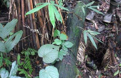 I have never seen this bird, and have recently begun to hear it less and less often. On Sunday 30 November, the reason for its gradual disappearance became clear, as I was walking with Robert Baldwin of Pancawati down the well-forested ridgeline of Pr Kramat, near to the village of Pancawati in sector B.
We were puzzled to see many holes in the ground beside the trail, that looked as if they had been dug recently with a shovel. At one of them, I saw an oddly-shaped inverted "basket" beside the hole. Our guide Pk Empad explained that this was an ingenious trap for the gonggong bird. There were actually two holes, one open and the other below the basket, with a "tunnel" between the holes. When in use, the open hole is to be covered with many leaves, so that a heavy walking bird might fall into the hole and fail to see any light above him. Instead, he would see light at the end of the tunnel, which would lead him to work his way into the second hole and thence up to the basket from which he could no longer escape.
"The gong-gong bird has become rare in the forest, most of them have gone to the city", joked the younger of our two guides. ("Burung gong2 sudah jadi langkah di hutan, kebanyakan di kota".)
 I have never seen this bird, and have recently begun to hear it less and less often. On Sunday 30 November, the reason for its gradual disappearance became clear, as I was walking with Robert Baldwin of Pancawati down the well-forested ridgeline of Pr Kramat, near to the village of Pancawati in sector B.
We were puzzled to see many holes in the ground beside the trail, that looked as if they had been dug recently with a shovel. At one of them, I saw an oddly-shaped inverted "basket" beside the hole. Our guide Pk Empad explained that this was an ingenious trap for the gonggong bird. There were actually two holes, one open and the other below the basket, with a "tunnel" between the holes. When in use, the open hole is to be covered with many leaves, so that a heavy walking bird might fall into the hole and fail to see any light above him. Instead, he would see light at the end of the tunnel, which would lead him to work his way into the second hole and thence up to the basket from which he could no longer escape.
"The gong-gong bird has become rare in the forest, most of them have gone to the city", joked the younger of our two guides. ("Burung gong2 sudah jadi langkah di hutan, kebanyakan di kota".)
Tuesday, November 25, 2008
Afloat in the Cisukabirus (B4)

Thanks John for that account. I just want to add a photo of our friend Jody Randall, enjoying his cool dip in the clear waters of the Cisukabirus beside the bamboo bridge in Jarimun (on route B4) on the crossing of the valley between Lemahneundeut and Arca. The cold water (must have been 22C or less) didn't seem to faze him, did it!
Sunday, November 23, 2008
Taman Safari to Arca
That stone road Alex describes from the Taman Safari entrance to Lemahneundeut is certainly a fine walk. In all the walks I've done using Alex's maps I hadn't realised you could enjoy such splendid forest scenery and broad views without ever leaving a broad and comfortable track! That particular section gives a real sweeping impression back towards Puncak and Gunung Pangrango and forward toward Bogor and Gunung Salak.
We also had the pleasure of stopping at Pak Nanang's organic farm in Lemahneunduet Tonggoh, which offered excellent hospitality and a range of delicious-looking vegetables. If we had been at journey's end we could have bought a few kilos of them, but as we had 5 km of walking ahead we had to refrain.
After Lemahneundeut Tonggoh we continued by crossing the Ci Sukabirus to the German cemetery at Arca, effectively a section of the B4 circle route in reverse. This is one of the deepest and broadest valleys on all the walks and the paddy fields in the bottom, always teeming with busy farmers and specked with multi-colored scarecrows, are truly beautiful.
Finding the path down and up the valley is probbaly easier from this direction than coming from Arca to Lemahneundeut. On the other hand, the section between the cemetery and the pine forest is probably much easier to follow if starting from the cemetery side as one section of the path above the pine forest on Pasir Pari is heavily overgrown.
I'm quickly discovering that practically any walk undertaken away from the paved roads in the in the mapped area will turn out to be delightful!
We also had the pleasure of stopping at Pak Nanang's organic farm in Lemahneunduet Tonggoh, which offered excellent hospitality and a range of delicious-looking vegetables. If we had been at journey's end we could have bought a few kilos of them, but as we had 5 km of walking ahead we had to refrain.
After Lemahneundeut Tonggoh we continued by crossing the Ci Sukabirus to the German cemetery at Arca, effectively a section of the B4 circle route in reverse. This is one of the deepest and broadest valleys on all the walks and the paddy fields in the bottom, always teeming with busy farmers and specked with multi-colored scarecrows, are truly beautiful.
Finding the path down and up the valley is probbaly easier from this direction than coming from Arca to Lemahneundeut. On the other hand, the section between the cemetery and the pine forest is probably much easier to follow if starting from the cemetery side as one section of the path above the pine forest on Pasir Pari is heavily overgrown.
I'm quickly discovering that practically any walk undertaken away from the paved roads in the in the mapped area will turn out to be delightful!
Tuesday, November 18, 2008
The End of an Idyll Nears
 Alex Korns posted this after walking on the Ring Route in Sectors C and B
The stone road from Citeko Panjang in sector C to Lemahneundeut Tonggoh in sector B, with its many hairpin turns, offers hikers a easy stroll through tea gardens and old stands of pine and damar with plenty of shade at an altitude of about 1000mdpl. This is one of the easiest walks in the mapped areas, nearly level, about 5-6km long, with views that delight far in excess of the modest effort that it takes to walk this road. On Sunday, 16 Nov, I had the pleasure of walking it with John Hargreaves and Jody Randall, who, I learned, have explored all of the circle routes on the 4 maps since early 2007. Not a single car passed us, and there were no other hikers. We saw two eagles soaring nearby amid the tea gardens.
Those of you who enjoy such walks had better do this road soon. Before long, if all goes according to plan, it will be an improved "alternative" asphalt road with high-speed traffic zipping from Gadog (at the end of the Jagorawi toll road) to Taman Safari. Our first hint of this was when we found the last half kilometer or so near Lemahneundeut to be well paved, for the first time since I hiked this road in the mid-Nineties. The road up from Pasir Muncang to Lemahneundeut Tonggoh has also been repaved. John was able to elicit the full story of this development scheme from a villager during a rest break.
Monkeys Sighted Again on Route B2 Pancawati
Robert (Baldy) Baldwin, who lives in Pancawati village, submitted this post.
Empad and I took off from my cabin in Pancawati village at 06:45. The weather was fine having rained most of the previous day, the views of Mt Salak and Pangrango majestic. Walking through the farmlands south of Pancawati village was a little discouraging, the locals crops have been hammered by viruses, with too much rain and fog. We got to the forest edge around 8:00 and heard monkeys calling off to the right. After a search through the trees we spotted a large black monkey sunning itself. After a few minutes, branches in surrounding trees started waving and we saw smaller grey monkeys frolicking around in the top of the canopy in Pasir Kramat.
After entering the forest we headed up Pasir Pancawati. The walk was pleasant as the tree cover shaded us from the sun and the forest floor was damp and cool. Upon reaching the top of the ridge we encountered another group of monkeys. Seeing us, a group of 5 or 6 black monkeys bolted from high in the canopy and disappeared from sight, leaving only the crashing sounds of cracking branches behind as they decided we were best avoided. After 2 and a quarter hours we emerged from the forest. It had been a couple of months since we’d passed through there and the grass was significantly higher.
By 11 o’clock we were at the chicken farm. We soon turned left on Jl LBC and after 200 meters turned right into the asphalt road at the top of Leuwilarangan ridge, the valley a lush green with new padi. Many villas here are owned by senior media folk, so I’m told. After about 700 meters we descended the valley to cross to Legok Nyenang. Awesome views until cloud rolled in and drenched us. No bridge over the stream, rock hopping is the order of the day, wet feet virtually guaranteed. By the time we got to the Modern Training complex it was raining heavily. On the Cikereteg main road we stopped for lunch at Pak Nip’s roadside stall. The food was hearty, the coffee great and the hole in the wallet tiny. After lunch we headed down to Lembur Pancawati to finish a couple of beers I’d left in the fridge at Fran’s place a week earlier. The beers were still cold and, as usual, the service superb.
Empad and I took off from my cabin in Pancawati village at 06:45. The weather was fine having rained most of the previous day, the views of Mt Salak and Pangrango majestic. Walking through the farmlands south of Pancawati village was a little discouraging, the locals crops have been hammered by viruses, with too much rain and fog. We got to the forest edge around 8:00 and heard monkeys calling off to the right. After a search through the trees we spotted a large black monkey sunning itself. After a few minutes, branches in surrounding trees started waving and we saw smaller grey monkeys frolicking around in the top of the canopy in Pasir Kramat.
After entering the forest we headed up Pasir Pancawati. The walk was pleasant as the tree cover shaded us from the sun and the forest floor was damp and cool. Upon reaching the top of the ridge we encountered another group of monkeys. Seeing us, a group of 5 or 6 black monkeys bolted from high in the canopy and disappeared from sight, leaving only the crashing sounds of cracking branches behind as they decided we were best avoided. After 2 and a quarter hours we emerged from the forest. It had been a couple of months since we’d passed through there and the grass was significantly higher.
By 11 o’clock we were at the chicken farm. We soon turned left on Jl LBC and after 200 meters turned right into the asphalt road at the top of Leuwilarangan ridge, the valley a lush green with new padi. Many villas here are owned by senior media folk, so I’m told. After about 700 meters we descended the valley to cross to Legok Nyenang. Awesome views until cloud rolled in and drenched us. No bridge over the stream, rock hopping is the order of the day, wet feet virtually guaranteed. By the time we got to the Modern Training complex it was raining heavily. On the Cikereteg main road we stopped for lunch at Pak Nip’s roadside stall. The food was hearty, the coffee great and the hole in the wallet tiny. After lunch we headed down to Lembur Pancawati to finish a couple of beers I’d left in the fridge at Fran’s place a week earlier. The beers were still cold and, as usual, the service superb.
Friday, November 14, 2008
Welcome to the Puncaktrek Collaborative Blog
Hi there. Evan here. Owner of the googlepages site:http://indonesia.outdoors.googlepages.com.

Alex wants to set up a collaborative site where all us Puncak Trekkers can swap ideas and info. And here it is! In my case, I like to post photos of of the various routes, that someone could print out and bring with them to make sure they are on the same track. I have purposely obscured giving clear directions how to do each trek, because we want to encourage trekkers to buy Alex's excellent mapguides. Some may say Rp500,000 is a lot of money to pay for some maps, but what we are paying for is Alex's 15 years of local knowledge. For people who hate wasting time trekking down dead end trails, the Puncak trekker's guidemaps are a blessing. I dont use a GPS or altimeter, I just depend on Alex's maps and trail notes. Cheers Evan www.nedbatam.com/daytrips

Alex wants to set up a collaborative site where all us Puncak Trekkers can swap ideas and info. And here it is! In my case, I like to post photos of of the various routes, that someone could print out and bring with them to make sure they are on the same track. I have purposely obscured giving clear directions how to do each trek, because we want to encourage trekkers to buy Alex's excellent mapguides. Some may say Rp500,000 is a lot of money to pay for some maps, but what we are paying for is Alex's 15 years of local knowledge. For people who hate wasting time trekking down dead end trails, the Puncak trekker's guidemaps are a blessing. I dont use a GPS or altimeter, I just depend on Alex's maps and trail notes. Cheers Evan www.nedbatam.com/daytrips
Subscribe to:
Posts (Atom)
